ժ Ҫ
���š�����˿��֮·���IJ��Ϸ�չ�����������м�����ͨ������ҵ���������������࣬��һ��������羭�ú�ó��֡���������ͨ���������ӡ��ذ�������ʩ�����ơ����������������Ƶ����⣬���´�-����ײ�¹�ʱ�з�����Ϊ���������İ�ȫͨ�����������谭������ͨ����ֻ���䱸���״����ͨѶ���豸�����Բ��ܼ�ʱ��Ч�ػ�ȡ������ˮ��ĺ�����Ϣ��Ϊ������ʻԱ�ṩ�������߲ο������-����ײ�¹ʷ���������������Ȿ�ĴӲt��Ϊ���ı������з�ʽ���������ô�������ͼ��ɼ�������ͼ��ƴ�Ӻ�ͼ������ָ�����о����ڴ�������ͼ�����Ĵ�-���������߷��������ĵĹ�����Ҫ�о��������£�
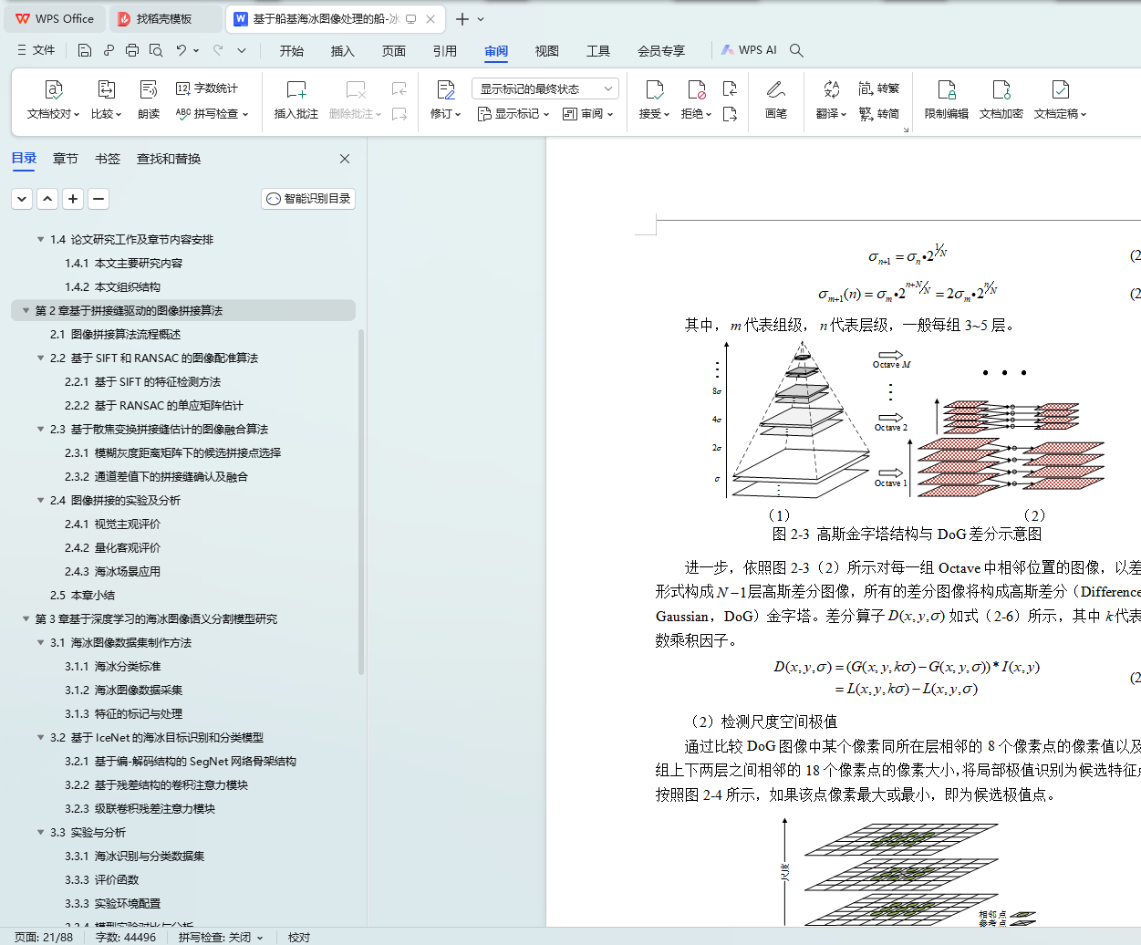
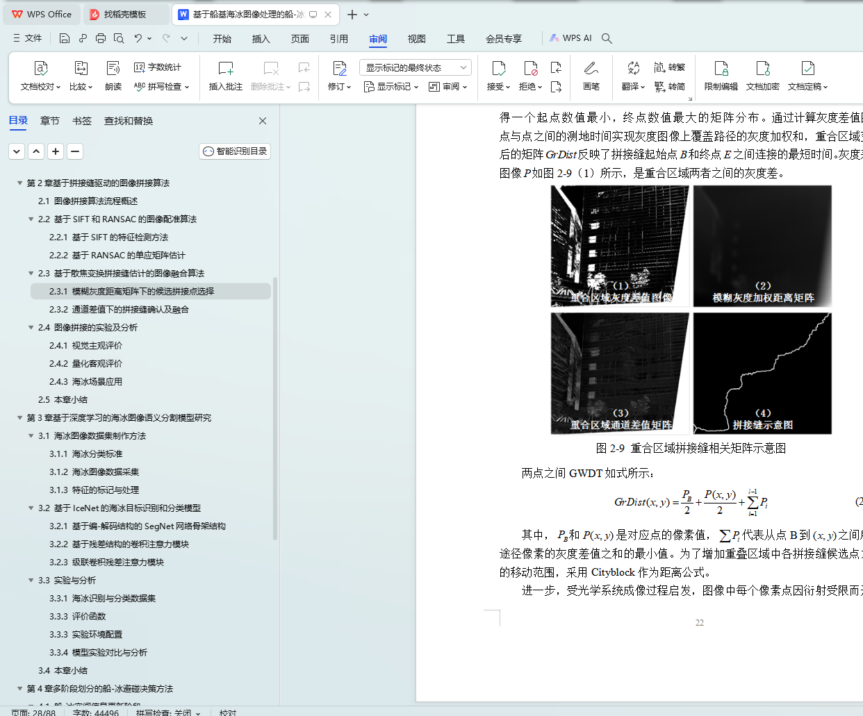
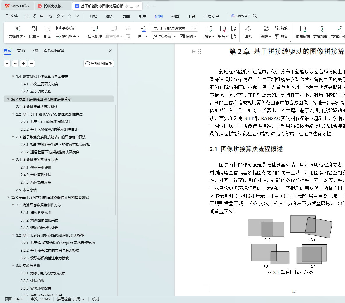
��1������ƴ�ӷ�������ͼ��ƴ���㷨�����ʵ�ʺ��й����д��ص�Ŀ����õ��Ĵ�������ͼ���ӳ���Χ��������⣬���ö��鲻ͬ�ӽ�����������ķ�ʽ����ȡ����Χ�ı�����Ϣ����������Ȼͼ��֮����ڵ��غ�����ͨ���߶Ȳ��������任��Scale Invariant Feature Transform��SIFT��������ȡ���������һ���ԣ�Random Sample Consensus��RANSAC�����ɸ���㷨����ͼ�������ڴ˻����Ͻ�һ������Ľ�ƴ�ӷ��������ݶ���ͼ���ں��㷨���ڶ�����ص�������Ѱ��һ�����ƴ�ӷ죬������ƴ��ͼ���еĴ�λ����Ӱ���õ������Ӿ������Ϳ��������۸��ŵĴ��ӳ��ϳ�ͼ��
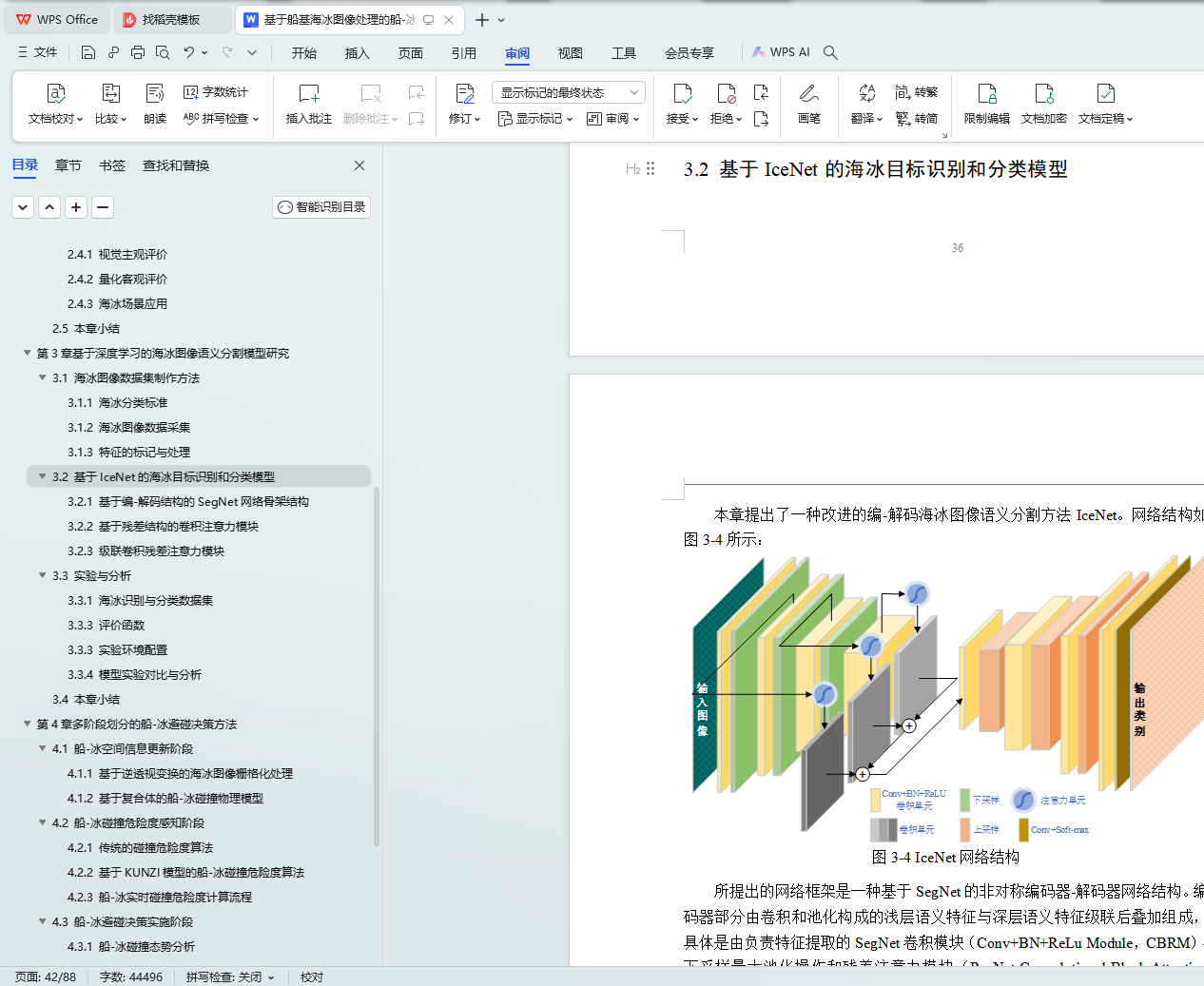
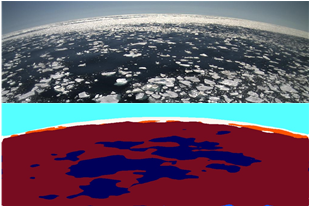
��2���������ѧϰ�ĺ���ͼ������ָ�ģ���о�������Բt��Ϊ���ı����������й����д�Ա�ں����۲�ʱ����������������⣬���һ�ֿ�ѵ����ͼ������ָ��ʶ�������ģ�ͣ�ʵ�ִ�������ͼ���к�������Ŀ��ټ�⡣���ȣ���ģ��ͨ���ƶ�һ�������ݼ����������ֱ���������ͼ������ʶ��ͷ������ݼ����������ڲ�ͬ����Ķ˵������ѧϰ�������ѵ������Σ�ģ�������õ�IceNet����ṹ��SegNet����Ǽ�Ϊ�������ڲ����Ӵ���ģ�Ͳ�����ǰ���£��ںϲв�ע����ģ�飬�����������ȴ�����ѵ���Ѻ�������������Ϣ���������⣬���շֱ�ʵ�ִ��ӳ���������ͼ���к���Ŀ���ʶ������ࡣ
��3����λ��ֵĴ�-���������߷�������Դ�����������ͼ���봬��ƽ����ӽDz������⣬���ݴ��������б���������µļ��ι�ϵ��������ͼ���еĺ������ؾ����ӱ任��Inverse Perspective Mapping��IPM����ӳ�䵽�������ڵ�����ռ�����ϵ�У��ٽ���դ����ͳһ��-��ʱ������ϵ����һ��ʵ�ֺ������������봬-����ײ����ģ�������ڴ˻����ϣ���ϴ����˶�����ģ�ͣ����û���KUNZIģ�͵Ĵ�-����ײΣ�նȷ����������趨��-����ײ���ո�����ֵʵ�ֶ�Σ�պ����Ķ�̬Ԥ�����ٽ�һ��������ײΣ�ճ̶Ƚ�����ײ̬�Ʒ����ƶ���Ч�ı������ԡ����������������ģ�����ֵ��ʹ�-����ײ̬���µ���ײΣ�ճ̶��жϺͱ����������̡�
�ؼ��ʣ���������ͼ������ͼ��ƴ�ӣ�ͼ������ָ��-����ײΣ�նȣ���������
Abstract
With the continuous development of the Ice Silk Road, the number of seasonally navigable commercial ships in the Arctic waterways has increased year by year, which has further deepened the world economy and trade pattern. However, due to the complicated navigation environment, imperfect coastal infrastructure, and limited ship technical conditions, ship-ice collision accidents have occurred from time to time, which has brought numerous obstacles to the safe navigation of the Arctic waterways. Although navigable vessels are equipped with radar, satellite communications and other equipment, they still cannot effectively obtain sea ice information in the navigating waters to remind ship pilots to pay attention to high-risk sea ice areas and provide collision avoidance decisions to avoid ship-ice collision accidents. Aiming at the above problems, this article starts from the observation-based navigation method in the ice area, makes full use of ship-based sea ice images, and uses image stitching and image semantic segmentation techniques to deeply study ship-ice collision avoidance decision-making methods based on ship-based sea ice image analysis. The main research work of this thesis is as follows:
(1) Image stitching algorithm based on stitch driving. Aiming at the problem of insufficient field of view of the ship-based sea ice image obtained by the ship-borne monocular camera during actual sailing, multiple sets of camera equipment with different viewing angles are set to shoot to obtain a larger range of ice rink information. The coincident areas between the natural images taken are used for image registration based on the SIFT feature extraction method and the RANSAC error point filtering algorithm, and an improved stitch-driven gradient domain image fusion algorithm is further proposed to find the best one in the aligned overlapping areas. Better stitching seams to eliminate the problems of misalignment and ghosting in stitched images, and to obtain composite images with better subjective visual evaluation and objective quality evaluation.
(2) Sea ice image semantic segmentation recognition and classification model based on deep learning. Aiming at the problem of subjective negligence in the observation of sea ice by the crew during the navigation of ships in the icy water where the observation is the mainstay, a trainable image semantic segmentation sea ice recognition and classification model is proposed to realize rapid detection of sea ice objects in ship-based sea ice images. First, this model develops a set of sea ice data set production standards to produce sea ice image semantic recognition and classification data sets, which are suitable for end-to-end deep learning network parameter training for different tasks. Secondly, the IceNet network structure adopted by the model is based on the SegNet network skeleton. Without increasing a large number of model parameters, the residual attention module is integrated to solve the problem of difficulty in training due to the depth of the network and the non-correlation of network context information. Finally, the recognition and classification of sea ice targets in the large field of view ship-based sea ice image are realized respectively.
(3) Multi-stage decision-making method for ship-ice collision avoidance. Aiming at the problem of different perspectives between ship-based sea ice semantic image and ship plane, the sea ice pixels in semantic image are mapped to the ship's world space coordinate system after inverse perspective transformation according to the geometric relationship of ship-based camera in oblique imaging condition. Then the rasterization process is performed to unify the ship-ice space-time coordinate system, and further realize the analysis of sea ice parameters and the construction of the ship-ice collision physical model. On this basis, combined with the probability model of ship's own motion state, the risk analysis method of ship ice collision based on kunzi model is adopted, and the risk threshold of ship ice collision is set to realize the dynamic early warning of dangerous sea ice, and then the collision state is analyzed according to the collision risk degree, and the effective collision avoidance strategy is formulated. Finally, the above method is used to simulate the collision risk judgment and collision avoidance decision-making process under two typical ship ice collision situations.
Key words: ship-based sea ice image processing, image stitching, image semantic segmentation, ship-ice collision risk, collision avoidance decision-making
Ŀ ¼
��1�� �� ��
1.1 ������Դ
1.2 �����о��ı���������
1.3 �����ⷢչ���о���״
1.3.1 ͼ��ƴ���о���״
1.3.2 ����ͼ������ָ��о���״
1.3.3 ������Ⱦ����������ͼ������ָ��о���״
1.3.4 ��-�������о���״
1.3.5 ��ǰ�о����ٵ�����
1.4 �����о��������½����ݰ���
1.4.1 ������Ҫ�о�����
1.4.2 ������֯�ṹ
��2�� ����ƴ�ӷ�������ͼ��ƴ���㷨
2.1 ͼ��ƴ���㷨���̸���
2.2 ����SIFT��RANSAC��ͼ�����㷨
2.2.1 ����SIFT��������ⷽ��
2.2.2 ����RANSAC�ĵ�Ӧ�������
2.3 ����ɢ���任ƴ�ӷ���Ƶ�ͼ���ں��㷨
2.3.1 ģ���ҶȾ�������µĺ�ѡƴ�ӵ�ѡ��
2.3.2 ͨ����ֵ�µ�ƴ�ӷ�ȷ�ϼ��ں�
2.4 ͼ��ƴ�ӵ�ʵ�鼰����
2.4.1 �Ӿ���������
2.4.2 ����������
2.4.3 ��������Ӧ��
2.5 ������
��3�� �������ѧϰ�ĺ���ͼ������ָ�ģ���о�
3.1 ����ͼ�����ݼ���������
3.1.1 ���������
3.1.2 ����ͼ�����ݲɼ�
3.1.3 �����ı���봦��
3.2 ����IceNet�ĺ���Ŀ��ʶ��ͷ���ģ��
3.2.1 ���ڱ�-����ṹ��SegNet����Ǽܽṹ
3.2.2 ���ڲв�ṹ�ľ���ע����ģ��
3.2.3 ���������в�ע����ģ��
3.3 ʵ�������
3.3.1 ����ʶ����������ݼ�
3.3.3 ���ۺ���
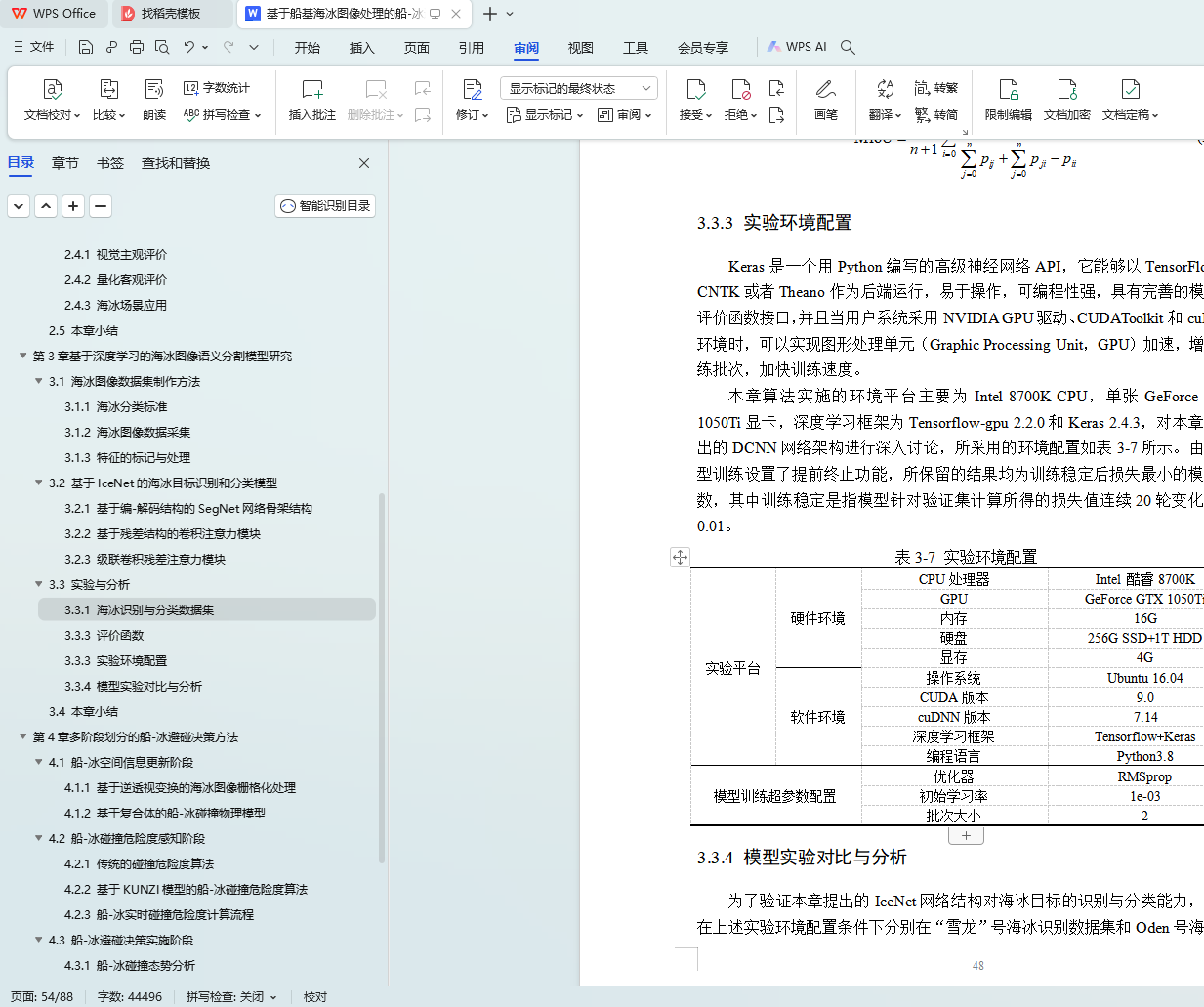
3.3.3 ʵ�黷������
3.3.4 ģ��ʵ��Ա������
3.4 ������
��4�� ��λ��ֵĴ�-���������߷���
4.1 ��-���ռ���Ϣ���½�
4.1.1 �������ӱ任�ĺ���ͼ��դ����
4.1.2 ���ڸ�����Ĵ�-����ײ����ģ��
4.2 ��-����ײΣ�նȸ�֪��
4.2.1 ��ͳ����ײΣ�ն��㷨
4.2.2 ����KUNZIģ�͵Ĵ�-����ײΣ�ն��㷨
4.2.3 ��-��ʵʱ��ײΣ�նȼ�������
4.3 ��-����������ʵʩ��
4.3.1 ��-����ײ̬�Ʒ���
4.3.2 ��-����������
4.4 ��-��������̬����ʵ��
4.4.1 ����������
4.4.2 ����ʵ�����
4.5 ������
��5�� �ܽ���չ��
5.1 ������Ҫ�о��ɹ�
5.2 δ������չ��
�� л
�����