基于80C51单片机的经纬度定位显示装置设计
摘要
全球定位系统(GPS)是以接收导航卫星信号为基础的非自主式导航与定位系统,具备全球覆盖、全天候、连续实时提供高精度的三维位置、三维速度和时间信息的能力,具有很好的导航和定位功能。GPS技术在军事、通讯、气象、勘探、导航、遥感、大地测量、地球动力以及天文等众多学科领域得到极其广泛的应用,推动了科学技术的迅猛发展,也丰富了人类的科学文化生活。现在,GPS的外型设计已经转向便携式发展,逐步踏入寻常百姓的生活中。所以,对GPS的研究具有十分重要的意义。
论文主要研究GPS接收机和80C51单片机串行数据通信的基本原理和实现GPS定位信息的接收和定位信息在LCD显示器的显示。完成了一台手持式GPS定位接收设备,并实时显示所在地的经纬度。该定位系统完成后,定位精度能达到15m,所以该装置在测控领域的应用开发中具有一定的实用价值和借鉴价值。
关键词:GPS;接收机;单片机;串行通信
DISPLAY EQUIPMENT DESIGN THAT LONGITUDE AND LATITUDE LOCATION BASED ON 80C51 SINGLE-CHIP
Abstract
Global positioning system (GPS) is receiving navigation satellite signal based the autonomous navigation and positioning systems, a global coverage, all-weather, continuous real-time three-dimensional position, with high precision of 3d speed and time information ability, has the very good navigation and positioning function. GPS technology in military, communication, meteorology, exploration, navigation, remote sensing, geodesy, earth power and astronomy etc many disciplines get extremely extensive application, promoted the rapid development of science and technology, enrich the human's science and cultural life. Now, GPS exterior design has turned to portable development, gradually step into people's lives. An Therefore, the research on GPS have very important significance.
Thesis mainly research GPS receiver and single-chip microcomputer serial data communication, the basic principle and realization of GPS positioning information received and positioning information in the LCD monitor displays. Completed a handheld GPS receiving equipment, and real-time display seat of the longitude and latitude. The positioning system is completed, 15m localization accuracy can reach, so this device in the measurement field of application development is of certain practical value and reference value.
Keywords: GPS ; Receiver; single chip microcomputer; Serial communication
目 录
摘要.....................................................................Ⅰ
Abstract..................................................................Ⅱ
1 前言 1
1.1 课题目的和来源 1
1.1.1定位和导航业务需求发展的趋势 1
1.1.2卫星定位和导航的作用 3
1.2开发系统及工具的选择 4
1.2.1 51单片机简介 4
1.2.2 proteus开发工具介绍 5
1.2.3 Keil uVision3 5
2 系统设计 5
2.1 系统结构 5
2.2 电源模块设计 6
2.3 GPS数据模块设计 7
2.3.1数据采集方案 7
2.3.2数据接收和处理 8
2.4 控制模块 9
2. 5显示模块 9
3 软件设计 10
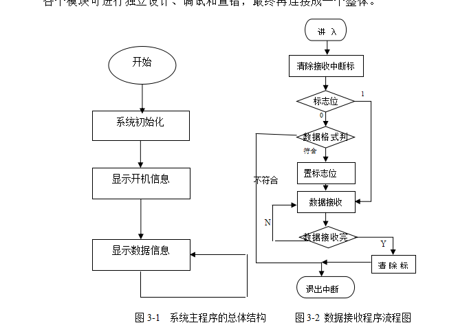
3.1 主程序设计 10
3.2 显示驱动程序 11
3.3 硬件连接设置 12
3.4 LCD显示工作模式 12
3.5 系统主程序 12
3.6 数据接收程序 13
结束语 19
参考文献 20
附录A:NMEA 0183格式资料...............................................22
附录B:程序清单........................................................23
致谢 32


